Ennore Fishers Stop TANGEDCO From Burying River, Mangroves

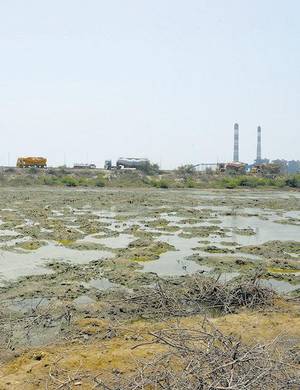
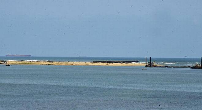
After government and regulatory agencies refused to stop TANGEDCO from destroying mangroves and encroaching into the Kosasthalai River, more than 200 men and women from Ennore’s fishing villages arrived in boats to the work site to protect the precious Konamudukku mangrove patch from being cleared. The coal conveyor corridor for TANGEDCO’s Ennore SEZ project has already encroached into more than 15 acres of wetlands, including 1.1 acre of river and mangroves. On 13 July, the Electricity Minister said TANGEDCO’s activities were perfectly legal. But the company’s activities do not have a valid Consent to Establish from TNPCB. Moreover, the electricity company has made false declarations to the Union Ministry of Environment, Forests and Climate Change to get approval for its coal conveyor corridor. After using an alignment that avoids waterbodies to get an approval, TANGEDCO has illegally altered the alignment without informing the Union environment ministry. The current alignment is unapproved and runs mostly on waterbodies and mangroves. 

Map Showing the Approved Alignment vs the Unlicensed Alignment Undertaken by TANGEDCO

If work continues at the current pace, the Konamudukku mangroves – identified as a No Development Zone in the approved 2018 Coastal Zone Management Plan (CZMP) – will be buried under 2 metres of sand within days. Local villagers complained that already one fishing ground locally known as padu — the Pazhaiyakal Pin Padu – has been buried by the ongoing encroachment.

Konamudukku is one of the most biologically productive patches remaining in the Ennore Pulicat wetlands. Five species of commercially valuable prawns – Vellra (white prawns), Mottra (Horned prawn), Kadamb Era (tiger prawn), Valchera (mud prawn) and Semakku Era (red prawns) – breed in the Konamudukku mangrove forests, making the waters around these mangroves among the choicest of fishing grounds. Besides fishermen who use boats, stake nets and hand cast nets, more than 2500 women from SC/ST communities earn a livelihood by hand-picking prawn and crab from mangroves such as this.

Fishers are disappointed with the government for refusing to stop TANGEDCO’s ongoing violation to save the environment and their livelihoods. “We know agencies like TNPCB will not dare regulate big and powerful violators. That is why we brought the matter to the notice of the district administration, and the environment and electricity ministers. Now, we are appealing to the Chief Minister because none of these people appear to care for our lives. We have already lost a lot to coal ash pollution by TANGEDCO and encroachments by roads, pipelines and infrastructure for power plants, coal yards and ports. Now, one of the last remaining sources of livelihood for us and numerous others including women fishers is being targeted. If Konamudukku mangroves and the deep waters around it are destroyed, we will be finished. It is telling about the state of affairs when all agencies of government are conspiring to commit an offence, and ordinary people are forced to intervene to enforce the law.” the fishers said.

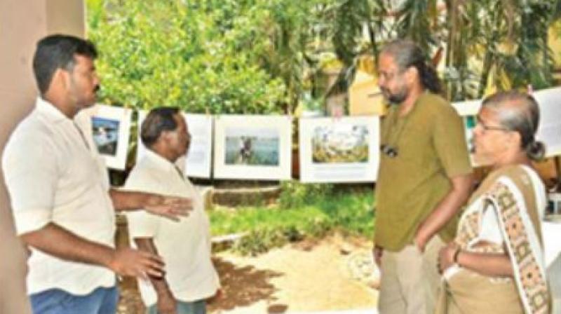
On 12 July, a team of three eminent citizens – including Prof. S. Janakarajan, musician and activist T.M. Krishna and Poovulagin Nanbargal’s G. Sundarrajan – visited two sites of ongoing encroachment and violations by TANGEDCO. In a report submitted by them to the Chief Minister, the three said that “TANGEDCO is misleading the government on its illegalities.” They warned that “The government needs to note that the already substantial liability, in terms of penalties, compensation for fisher livelihoods and harm to health, remediation costs and criminal prosecution of TANGEDCO officials will be magnified if corrective action is not taken immediately.” 

Villagers and city-based activist groups such as Save Ennore Creek campaign have asked the government to ensure that the ongoing work is stopped, the damage to ecology reversed and fisherfolk compensated for the damage to their livelihoods.

For more information, contact: K. Saravanan: 9176331717. Nityanand Jayaraman: 9444082401 (Save Ennore Creek Campaign)

R.L. Srinivasan: 9962733450. Fisherman, Ennore

Read More »

Ennore Creek exists: Fisher protests redrawn ‘fake’ map that denies livelihood

The fisher folk called this India’s biggest water scam and said that they would continue protesting until the map is withdrawn.

The fishing community at Ennore Creek formed a human chain on Wednesday to protest against a map drawn by the Department of Environment that depicts the 6,469 acres of wetland area as a petrochemical plant.

Standing in the Kosasthalai River, the protesting men, women and children called it India’s biggest water scam yet.

Read More »

Time to change course

Chennai city will have no future if plans to fill the Ennore creek go ahead

ennoreblogimage2

Since December 2015, Chennai has limped from one extreme weather-related shock to another — the floods, the failed monsoon of 2016, Cyclone Vardah, and now the water crisis. Chennai’s defining element is water. But the city shows scant regard for this precious but dangerous resource. Located squarely in the intervening floodplains of three rivers on a high-energy coastline, Chennai is a disaster-prone location. Any badly located city can be vulnerable merely by virtue of its location. But only a special kind of city — a city with a death wish — actively makes a bad situation worse.

Nothing speaks more elegantly to Chennai’s death wish than what governments are doing to the wetlands in North Chennai. In June, the State government conceded the Government of India-owned Kamarajar Port Ltd’s (KPL) request to divert 1,000 acres of the hydrologically sensitive Ennore wetlands for industrial installations that are best built on dry land. The proposal is pending Central government clearance. If permitted, KPL’s dream will turn out to be Chennai’s worst nightmare, far worse than the 2015 floods.

The importance of Ennore

Ennore Creek, a sprawling 8,000-acre tidal waterbody, is a place where climate change and disastrous land-use change converge. Two rivers with a total catchment of 5,000 sq km empty into the Ennore Creek.

This wetland’s importance may not be apparent. Much of the creek looks dry year-round, when visible waterspread is only 1,000 acres. But when cyclonic weather pushes the sea surging landwards, or when rainwaters from the two rivers come rushing to meet the sea, the waterspread in the creek swells to its majestic fullness. Come rain or storm surge, the availability of room for the rain or sea water to stay is what keeps the city from going under.

The creek offers another protection too. It buffers the rich aquifers of the Araniyar-Kosasthalaiyar Basin from the sea, and keeps salt water from invading groundwater resources that supply several hundred million litres daily to Chennai even during the worst droughts.

In 1996, the Tamil Nadu government protected a 6,500-acre stretch of the tidal waterbody under the Coastal Regulation Zone (CRZ) Notification. But greed prevailed over good sense. More than 1,000 acres of the creek were lost to illegal encroachments that rise like dams across a river.

The offending installations block the path of rainwaters rushing down the Arani river and the mighty Kosasthalaiyar. Areas that never got flooded saw waters enter homes and remain for more than a fortnight in 2015. Tamil Nadu’s lifeline, the Manali petroleum refinery, went under water for days.

Read More »

‘Illegal map used to clear port plan in Ennore creek’

CHENNAI: The Tamil Nadu State Coastal Zone Management Authority (TNSCZMA) has used a fraudulent CRZ map to facilitate industrial activity in Ennore creek, allege activists.
“Using this map, the TNSCZMA has diverted around 1,000 acres in the creek to facilitate a proposal by Kamarajar Port Ltd,” said Pooja Kumar from Coastal Resource Centre, referring to RTI responses received from the Department of Environment, Tamil Nadu, and the Ministry of Environment, Forests & Climate Change, New Delhi on June 22.

On the allegation of using the wrong map, the member secretary, TNSCZMA, H Malleshappa said through the RTI response that he had furnished a map that was ‘revised and approved by Government of India in 1997.’Malleshappa’s response referred to a letter in 1997, in which the Government of India had permitted the TN government to revise the boundaries of Ennore creek, based on a survey by the Naval Hydrographer. He was, however, unavailable for comments despite repeated calls.

A subsequent RTI response from the Department of Environment dated July 20, however, exposed that the Department did not approach the Chief Hydrographer to demarcate the backwater areas. “In 1997, the Department of Environment did not approach the Chief Hydrographer to demarcate the backwater areas,” the response said. Further it revealed that subsequent to the letter dated 30.9.1997, no modification has been done.

Read More »

Ennore Creek falls off map, activists cry foul

Does the Ennore Creek exist or not? As per two RTI replies given by the Department of Environment, it exists and it doesn’t exist.

According to Jesu Rathinam of the Coastal Action Network, in the first RTI reply, a map provided by the Department of Environment, declaring it as approved by the Government of India, showed 6,469 acres of the Creek to be a tidal waterbody protected as a No Development Zone under CRZ-I regulations.

In response to another RTI this year, another official map shows that the entire Ennore Creek has disappeared.

The Coastal Action Network (CAN), the Coastal Resource Centre, the Save Ennore Creek Campaign and Ennore fisherfolk groups want an independent investigation into the functioning of the State Coastal Zone Management Authority and the Environment and Forests Department.

Environment activist Nityanand Jayaraman said as per the map given that now, more than 6,000 acres of the creek will vanish.


Read More »

Ennore creek erased from govt map, allege activists

CHENNAI: Two maps of the city given to environment activists based on RTI applications appear contradictory. The first, approved by the Centre in 1996, showed the presence of Ennore creek, spread over 6,569 acres, while the second does not have the creek at all.

Coastal Resource Centre founder Nityanand Jayaraman said it was the surprising that the creek, shown as a water body protected as a ‘no development zone’ under CRZ1 in the map presented after an RTI application filed in 2009, was completely missing in the map given after an application filed this year following a controversy over diversion of the Ennore wetlands.

Releasing both maps at a meeting here on Friday, the Coastal Action Network, Coastal Resource Centre, Save Ennore Creek Campaign and Ennore fisherfolk demanded an independent probe into the functioning of the State Coastal Zone Management Authority. The creek, they said, protected Thiruvottiyur, RK Nagar, Madhavaram and Ponneri areas from flooding.

Read More »

Ennore Creek falls off map, activists cry foul

ennorepost4
Contradictory claims:Two RTI queries have yielded different responses on the existence of the Ennore Creek.R_Ragu | Photo Credit: R. Ragu

Say it would pave the way for takeover by realtors

Does the Ennore Creek exist or not? As per two RTI replies given by the Department of Environment, it exists and it doesn’t exist.

According to Jesu Rathinam of the Coastal Action Network, in the first RTI reply, a map provided by the Department of Environment, declaring it as approved by the Government of India, showed 6,469 acres of the Creek to be a tidal waterbody protected as a No Development Zone under CRZ-I regulations.

In response to another RTI this year, another official map shows that the entire Ennore Creek has disappeared.

The Coastal Action Network (CAN), the Coastal Resource Centre, the Save Ennore Creek Campaign and Ennore fisherfolk groups want an independent investigation into the functioning of the State Coastal Zone Management Authority and the Environment and Forests Department.

Environment activist Nityanand Jayaraman said as per the map given that now, more than 6,000 acres of the creek will vanish.


Read More »

Ennore Creek is ‘Petrochemical Park’ in new CRZ map

CHENNAI: The new Coastal Regulation Zone (CRZ) map of Tiruvallur district has marked the 6,400-acre Ennore Creek as “Petrochemical Industrial Park”. Activists fear this is a backdoor attempt to industrialise the creek, an ecologically sensitive area where the Kosasthalaiyar River meets the sea.

The new map was accessed through the Right to Information (RTI) Act. Despite it being the most important document that to would regulate the development along the coastal area, there was no mention of when the map was prepared and by whom.
The new map is in sharp contrast to the 1996 map, which shows the 6,469 acres of Ennore Creek to be a tidal water body and protected as No Development Zone under CRZ-1.

Sharing the documents at the press meet on Friday, members of Coastal Action Network (CAN), Coastal Resource Centre, Save Ennore Creek Campaign and All Ennore Fishing Villages (AEFV) coalition demanded an independent probe into the working of the State Coastal Zone Management Authority and the Department of Environment.

Jesu Rathinam of CAN said she got the copy of the 1996 map in 2009 after struggling for three years. “Also, the map obtained by us covers a stretch of 16 km, while the latest map covers only 13 km and makes it seem as if there is no Creek in the map area,” she said.

Read More »

RTI reveals Chennai’s largest estuary Ennore Creek missing in the latest CRZ map

A 1996 CRZ map obtained by Jesu Rathinam of Coastal Action Network under RTI in 2009 from the Department of Environment shows 6,469 acres of Ennore Creek to be a tidal water body protected as ‘No Development Zone’ under CRZ 1.

Two widely conflicting maps of the Chennai’s largest estuary Ennore Creek, both of which were presented as Government of India-approved Coastal Regulatory Zone maps in two separate RTIs, have exposed serious irregularities and possible fraud in the functioning of the State Department of Environment.

A 1996 CRZ map obtained by Jesu Rathinam of Coastal Action Network under RTI in 2009 from the Department of Environment shows 6,469 acres of Ennore Creek to be a tidal water body protected as ‘No Development Zone’ under CRZ 1. However, the entire Ennore Creek has disappeared in the latest map received in response to a RTI petition in 2017 after controversy erupted over diversion of Ennore wetlands.

“Since both maps have been obtained under RTI, the Department of Environment has falsified information in one of the two cases. That is a punishable offence under the RTI Act,” said Jesu Rathinam, Convenor of the Coastal Action Network.

Read More »

How can Ennore Creek go missing in map?

Reply from the department of environment denies the existence of the Ennore creek.
ennorepost3

Activists examine the map showing Ennore creek at Chennai Press Club on Friday. (Photo: DC)

Chennai: When the environmental activists are crying foul over the exploitation of Ennore creek, a new revelation brought out through the Right to Information reveals shocking facts.  While the government approved map obtained through RTI by Jesu Rathinam of Coastal Action Network (CAN) in 1996 shows 6,469 acres of the Ennore creek as a No-Development Zone under CRZ-1, another reply from the department of environment denies the existence of the Ennore creek.

Pooja Kumar of Coastal Resource Centre (CRC), said, “The map that we (CRC) acquired through RTI in 2017 covers only 13 km and the entire Ennore creek had disappeared. But the map obtained by Coastal Action Network covers a stretch of 16 km and is consistent with the Coastal Zone Management Plan that identifies Sheet 2, Tiruvallur district.” Condemning the offence, Jesu Rathinam of CAN said, “Since both maps have been obtained under the RTI, the department of environment has falsified the information in one of the two cases. This is a punishable offence.”

The fishermen from Ennore and the environmentalists from CAN, CRC and Save Ennore Campaign on Friday demanded an independent probe into the functioning of the State Coastal Zone Management Authority and the department of environment. Environmentalist Nityanand Jayaraman said, “There should be one map, but there are two maps which are government-approved. While one is legitimate, the other one is clearly a lie. Two different complaints have been filed before Information Commission and State Disaster Management Authority.”

Read More »